
Planning data
Practical visit facts
- Route or distance
- Official guided route from Finca Monte Calas: approximately 4.5 km uphill and 4.5 km downhill.
- Suggested time
- About 5 hours, plus registration and travel to base camp.
- Admission and booking
- Accredited guide required; book ahead and pay SINAC admission separately by card.
- Available facilities
- SINAC reports no facilities: carry 2 litres of water, food, warm layers, waterproofs and the required equipment.
Distances, hours, access and facilities may change because of weather, maintenance or operating decisions. Always confirm with the official source before leaving.
Content reviewed on July 28, 2026Practical decision
Is it right for your trip?
Choose Turrialba for a demanding guided hike to viewpoints over an active volcano. Do not treat it as a quick substitute for Irazú or select it when an accessible route is required. The experience depends on a guide booking, an early departure and the ability to complete approximately 9 km in mountain conditions.
Official trails: how they differ
Finca Monte Calas–crater sector · approximately 9 km return
The authorised operation publishes roughly 4.5 km uphill and 4.5 km downhill, usually taking about five hours. This is not an independent hike: the group must remain with its accredited guide throughout.
Summit viewpoints
The objective is to use authorised points overlooking the craters and regional landscape, not to enter a crater or leave the route. Exact access may change because of gas, wind, activity or emergency instructions.
Sunrise and sunset · special dates
The authorised operator lists occasional special departures, but these are not part of the ordinary daily schedule. They must be explicitly available and booked; never arrive outside normal hours expecting to join.
How to choose a route
The daytime hike is appropriate for a first visit. Sunrise or sunset makes sense only for visitors accepting partial darkness, extra cold and limited dates. If you cannot complete the route or volcanic restrictions apply, use legal regional viewpoints or visit Guayabo instead of seeking clandestine farm access.
How much time to allow
SINAC lists operating hours of 05:00–10:00 in the dry season—December to April—and 06:00–10:00 in the rainy season—May to November. These are departure windows, not the total visit. Report to Finca Monte Calas at least 30 minutes early; the activity usually takes about five hours, and late arrival may forfeit the booking.
Visibility, rain and terrain
Above 3,000 m, cold, UV, rain and wind can occur together. Use layers, waterproofs, suitable trousers, mountain footwear with grip, sunscreen and pack protection. Wind direction also controls gas exposure and may alter the route. A general forecast for Turrialba town is not a summit guarantee.
Mobility and real accessibility
SINAC states that visitors with mobility difficulties are not admitted because of the hike’s difficulty and their vulnerability during an emergency. The route combines sustained ascent, altitude and natural terrain. Ask the operator about age, health and equipment restrictions before booking; respiratory or cardiovascular conditions and recent injuries merit professional advice.
Common mistakes on this visit
- Going directly to a park entrance without first booking the authorised guiding service.
- Confusing the guide fee with SINAC admission, which is paid separately at the gate by card only.
- Blindly following GPS through Calle Vargas: the operator recommends La Pastora for regular vehicles and reserves Calle Vargas for four-wheel drive.
- Counting only the 4.5 km ascent and forgetting the descent, elevation and roughly five-hour total.
- Arriving without the recommended two litres of water and energy food when SINAC reports no visitor facilities.
- Removing or incorrectly using protective equipment during the route.
- Leaving the group for crater photographs or following an unauthorised route found in a hiking application.
- Booking rafting, Guayabo or another strenuous activity immediately after the hike.
A realistic day for climbing Turrialba
- The day before: confirm departure with the guide, park opening, route to Monte Calas, equipment, hydration and payment methods for admission and parking.
- Thirty minutes early: register at base camp, attend the equipment check and do not force the departure if ill or injured.
- First 2–3 hours: ascend with the group, conserve energy and follow instructions about gas, pauses and equipment.
- Summit section: remain only at authorised viewpoints; a guide or ranger decision to turn back takes priority over the itinerary.
- Descent and afternoon: return to Monte Calas, rehydrate and choose a quiet extension around Santa Cruz or Turrialba rather than another risk activity.
How it formed and works
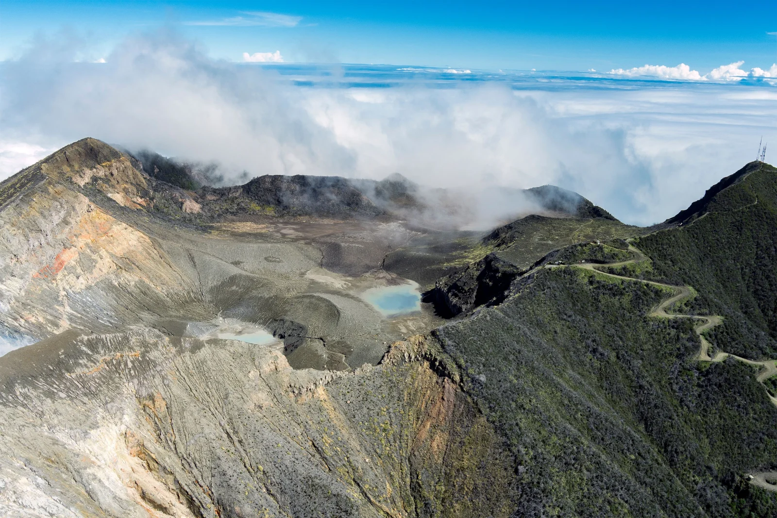
Turrialba is a complex stratovolcano approximately 3,340 m high that shares its base with Irazú, although it belongs to a parallel volcanic alignment within the Central Range. Its summit contains an avalanche depression with three main craters and other structures reshaped by erosion and eruptions. Lava flows, ash and pyroclastic-flow and surge deposits cover the flanks. Active faults cut the edifice, so understanding it requires both landscape observation and instrumental monitoring.
Landscape and ecosystems
The authorised ascent connects highland farms and pasture with montane forest, vegetation affected by gas and an open, exposed summit environment. Clear days may reveal Turrialba Valley, Caribbean lowlands, other Central Range volcanoes and the Talamanca peaks. Fog, rain and wind can replace those views within minutes, yet regeneration and evidence of activity remain meaningful when the horizon disappears.
Eruptive and human history
Turrialba had a documented eruptive period from 1864 to 1866. After decades of changes in seismicity and gas, a new vent opened in January 2010 and began a phase involving ash emissions, explosions and strong degassing. Activity during 2014–2017 affected farms and communities and caused airport closures in the Central Valley. Its later tourism reopening did not restore unrestricted access: it established a controlled route, mandatory guiding and protective equipment.
What you will find
- Massif landscape and controlled observation near the crater area.
- Recent eruptive history and Santa Cruz highland farming communities.
- Caribbean or Central Valley views only when weather permits.
Plan your visit
- Check official status before leaving; activity can change access at short notice.
- The published official approach is through Tapojo on cantonal route 020 via Finca Monte Calas.
- The park states that it has no visitor facilities, so arrive self-sufficient.
Access and logistics
High rural roads may have fog, mud and operational changes. Use only the SINAC-recognized entrance; private access does not authorize entry into closed park areas.
Safety and volcanic activity
Gas, ash, wind, cold and eruptive changes are real hazards. Tourist opening does not mean inactivity. Obey closures and check both SINAC and volcano-monitoring reports.
Hours, rates, trails and conditions can change without notice. Official park information and staff instructions always take precedence.What to explore nearby
- Santa Cruz de Turrialba and La Pastora provide context for the dairy and agricultural landscape living beside the volcano.
- Turrialba town is the most complete base for accommodation, food and supplies, but reaching Finca Monte Calas takes additional time.
- Guayabo National Monument deserves another day; combining a five-hour hike with Pacuare rafting is not prudent planning.
Specific sources and editorial review
Operational information reviewed 31 July 2026. Turrialba is active: confirm opening, departure, authorised route, equipment and the latest scientific bulletin immediately before travelling.