
Planning data
Practical visit facts
- Route or distance
- Craters has a short route at 3,432 m; Prusia is a separate entrance with about 16 km of roads and trails.
- Suggested time
- 1–2 hours at Craters; 4–6 hours to combine routes in Prusia.
- Admission and booking
- Book only through SINAC for the correct sector; published last admission: 14:00 Craters and 13:00 Prusia.
- Available facilities
- Craters has parking, a café and adapted toilets; Prusia provides water, toilets and picnic areas.
Distances, hours, access and facilities may change because of weather, maintenance or operating decisions. Always confirm with the official source before leaving.
Content reviewed on July 28, 2026Practical decision
Is it right for your trip?
Choose Craters for a short, accessible visit focused on volcanic scenery. Choose Prusia if hiking in highland forest is the priority. Booking one does not book the other, and trying to explore both properly in a single morning rarely works.
Official trails: how they differ
Craters Sector
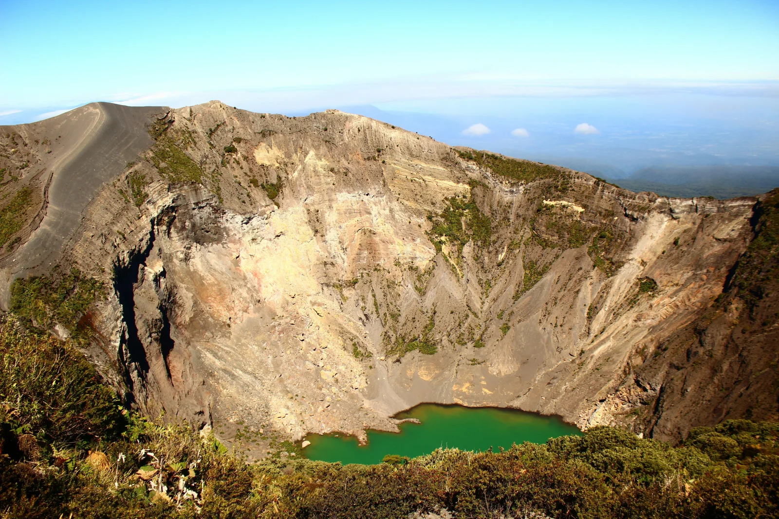
A short route from the car park to viewpoints over the main crater and Diego de la Haya. It is the easiest option, but it takes place at 3,432 m and remains exposed to cold, wind, UV and fog.
Prusia · shorter routes
The official map references options such as Micaela, La Gruta, Los Abuelos and Mirador at about 800 m each, plus El Puriá at roughly 600 m. Confirm which paths are open and how they connect at the entrance.
Prusia · longer routes
Official material shows El Roble at about 3.4 km, Chiverrales at 2.1 km and Parquecito at 1.5 km. The actual day is longer once connecting paths and the return to the trailhead are included.
How to choose a route
For a first visit, Craters is the clearest choice. Prusia suits visitors who know how far they want to walk and carry suitable footwear, water and warm layers. To visit both, purchase the correct admission for each sector, account for the transfer between entrances and reserve most of the day.
How much time to allow
Allow 1–2 hours for Craters, including parking, admission control and observation time. Give Prusia at least half a day; a combination of longer trails can take 4–6 hours. SINAC currently publishes daily opening from 08:00 to 16:00, with last admission at 14:00 for Craters and 13:00 for Prusia.
Visibility, rain and terrain
The summit can cloud over quickly, and SINAC warns that crater views are not guaranteed and weather-related ticket refunds are not available. Early arrival may improve the odds but is not a promise. Carry a windproof warm layer and rain protection even when Cartago is sunny, plus sunscreen for the intense high-altitude UV.
Mobility and real accessibility
Craters has adapted toilets and a short route towards the viewpoint, making it one of the country’s more accessible volcanic encounters. Nevertheless, altitude can cause headache, dizziness or breathlessness. Walk slowly and descend if symptoms worsen. Prusia involves natural surfaces, gradients and substantially longer distances.
Common mistakes on this visit
- Buying admission for Prusia when the intended visit was the craters, or the reverse.
- Assuming the crater lake always contains water or matches promotional photographs.
- Arriving without a booking because the Craters route appears short.
- Underestimating 3,432 m and walking quickly immediately after arrival.
- Using Cartago’s weather as the basis for summit clothing.
- Combining Prusia trails using only their individual lengths without adding connections and the return.
- Feeding coatis or raccoons in picnic areas; SINAC expressly prohibits feeding wildlife.
A realistic day between Irazú and Cartago
- 07:00–08:00: travel towards the booked sector after arranging breakfast and drinking water before the climb.
- 08:00–10:00: visit Craters; move slowly, observe summit conditions and do not wait indefinitely for fog to clear.
- 10:30–12:00: descend through Tierra Blanca and stop at an established business or permitted area rather than parking on bends or entering farms.
- 12:00–15:30: downtown Cartago, the Basilica and parish ruins. If you chose Prusia, replace this section with hiking and do not attempt to add Orosi.
- After 15:30: return or continue towards Orosi only if daylight and energy permit; it is not an obligatory part of the day.
How it formed and works
At 3,432 metres above sea level, Irazú is Costa Rica’s highest volcano. The National Seismological Network describes it as a complex volcanic shield: several edifices grew, were partly destroyed and were overlain by later cones. The summit contains the main crater, Diego de la Haya, Playa Hermosa and other pyroclastic structures. The main crater lake is not permanent; its presence, depth and colour change, so an older photograph cannot predict what will be visible during a visit.
Landscape and ecosystems
The Craters Sector is open, cold and windy, with ash, scoria, low vegetation and little shelter from sun or rain. SINAC lists a mean annual temperature of only 5–9 °C, while wind can make it feel colder. Prusia belongs to the same park but offers the opposite experience: montane forest, picnic areas and a road-and-trail network totalling about 16 km. The two sectors should not be treated as adjacent entrances.
Eruptive and human history
The eruptive phase that began in 1963 spread ash over parts of Cartago and the Central Valley and continued intermittently until 1965. Material deposited on the slopes also contributed to lahars that severely affected Taras, Cartago. Fumaroles and seismic episodes have been recorded since, but visible conditions on a given day do not replace scientific monitoring. This history explains why designated areas must be respected even when the crater appears quiet.
What you will find
- Main crater and Diego de la Haya crater.
- Ash, scoria and vegetation shaped by wind and elevation.
- Prusia Sector forest trails under a separate ticket and schedule.
Plan your visit
- Buy an online ticket for the correct sector: Craters or Prusia.
- The park opens daily, but published last-entry times are earlier than closing.
- Arrive early; cloud often builds and temperatures shift quickly.
Access and logistics
A paved road reaches the Craters Sector from Cartago. Prusia uses a different turn through Potrero Cerrado. Allow for driving, sector-specific last entry and hiking time.
Safety and volcanic activity
Above 3,400 m, cold, wind, strong UV and altitude discomfort are possible. Walk slowly, hydrate and carry sun and rain protection. Never descend into the craters.
Hours, rates, trails and conditions can change without notice. Official park information and staff instructions always take precedence.What to explore nearby
- Downtown Cartago, the Basilica of Our Lady of the Angels and parish ruins to complete a short day.
- Tierra Blanca, Potrero Cerrado and Pacayas for highland farming landscapes without treating private farms as improvised viewpoints.
- Orosi Valley and Ujarrás as a separate cultural trip; adding them after Prusia usually creates a rushed itinerary.
Specific sources and editorial review
Operational information reviewed 31 July 2026. Trails, weather, access and hours can change; confirm them with SINAC before departure.